2007 RAINFALL
2008
|
94549 - KINGAROY AIRPORT - 151.8398°E, 26.5737°S, 434m ASL KINGAROY Town - 151.5072°E, 26.3232°S, 437m ASL The rainfall ( in mm ) reported here is read from a commercial rain gauge mounted in the open on a post 2 metres off the ground at our home in Kingaroy itself, some 5km from the Kingaroy Airport. Here is a link to our States' water resources. (The Dam closest to our area is the Bjelke-Petersen Dam) The worst drought in over 100 years MAY be coming
to an end - though in our area we are STILL waiting as other areas
flood. Readings are taken at 9.00 am |
| Date | Jan | Feb | Mar | Apr | May | Jun | Jul | Aug | Sept | Oct | Nov | Dec |
| 1 | 1 | 1 | ||||||||||
| 2 | 1 | 11 | ||||||||||
| 3 | 3.5 | 1 | 10 | |||||||||
| 4 | 10 | 17 | 5 | 3 | ||||||||
| 5 | 1.5 | 60 | .75 | 12 | ||||||||
| 6 | 30 | 1 | 4 | 9 | 16 | |||||||
| 7 | 31 | 4 | 10.5 | |||||||||
| 8 | 40 | 5 | 31 | 4 | 12.5 | |||||||
| 9 | 18 | 14 | ||||||||||
| 10 | 1.5 | 2 | ||||||||||
| 11 | 16 | 13 | ||||||||||
| 12 | 18 | 11 | 1 | |||||||||
| 13 | 8 | 2 | ||||||||||
| 14 | 5.5 | 1 | 2 | |||||||||
| 15 | ||||||||||||
| 16 | 1 | 1.5 | 2 | 7 | ||||||||
| 17 | 2.75 | 2 | ||||||||||
| 18 | 1.5 | 6 | ||||||||||
| 19 | 1 | 15 | ||||||||||
| 20 | 1 | 54 | ||||||||||
| 21 | 5 | 5.5 | ||||||||||
| 22 | 5 | 1.5 | 3 | |||||||||
| 23 | 3.5 | |||||||||||
| 24 | 28 | |||||||||||
| 25 | 11 | 6 | ||||||||||
| 26 | 6 | .5 | ||||||||||
| 27 | 13 | 3 | 6 | .5 | ||||||||
| 28 | 6.5 | 10 | 2 | 4 | 58 | |||||||
| 29 | 1.5 | 9 | 2 | 1.5 | ||||||||
| 30 | 23 | 4 | ||||||||||
| 31 | 11 | 11 | ||||||||||
| Monthly Totals | 115.5 | 189 | 22 | 2.5 | 34 | 32 | 92 | 8 | 24.5 | 28 | 116 | 121.5 |
| Days Rained | 13 | 14 | 3 | 2 | 2 | 5 | 12 | 2 | 4 | 6 | 9 | 10 |
| Cumulative Rainfall | 115.5 | 304.5 | 326.5 | 329 | 363 | 395 | 487 | 495 | 519.5 | 547.5 | 663.5 | 785 |
| Cumulative Days Rained | 13 | 27 | 30 | 32 | 34 | 39 | 51 | 53 | 57 | 63 | 72 | 82 |
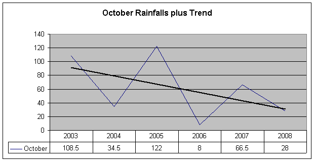
Here is a link to the graphs as shown below. Thanks to
|
Last Updated : 28/01/2012 11:43 AM +1000