KALUMBURU

BARNETT GORGE


Day 16

Thursday 29th July


  • Drove to Honeymoon Beach and waited in case Peter and Sue arrived
     
  • Drove to Mitchell River Road/Kalumburu Road turn
     
  • CAMPSITE - Mitchell River Road /Kalumburu Road turn - Dingo in food
  • Latitude    14° 6'16.26"S
  • Longitude 126°40'49.35"E

     
  • Latitude    15° 8'59.58"S
  • Longitude 126°12'10.23"E 


Day 17

Friday 30th July

 
  • Miners Pool Camping area - Met Peter and Sue again
     
  • Travelled to Barnett River Gorge
     
  • CAMPSITE -  Barnett River Gorge
  • Latitude    15°40'52.62"S
  • Longitude 126°24'15.90"E
     
  • Latitude    14° 8'45.54"S
  • Longitude 126°38'56.27"E
Day 18

Saturday 31st July

 
  • Explored Barnett River Gorge
     
  • CAMPSITE -  Barnett Gorge
 
  • Latitude    14° 8'45.54"S
  • Longitude 126°38'56.27"E


(Updating so text is not in context with days)
13-08-2009


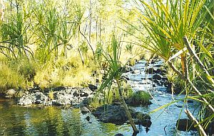
On the way back to the Gibb River Road we camped near the turnoff to the Mitchell Falls.

The next day we continued on to the Barnett River Gorge                                                        


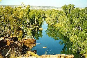
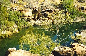
Northern View of Barnett Gorge


Southern View of Barnett Gorge

This was the view as we sat on the rocks high
above the Barnett Gorge.

Our camp was
situated where the water forms an inverted V
in the left picture.


The picture below - where the water from the gorge cascades over rocks past Pandanus Palms -  was taken from our campsite. Parrots with their raucous call hung from the trees as I took this shot.
It was one of the most beautiful campsites we had on our trip.


Last Updated : 28/01/2012 03:23 PM +1000